Complete situation map for fast and adequate action
sd-kama (Smart Data Katastrophenmanagement) is an information platform for relief forces in the field of disaster management and control, that is currently under development. The platform provides access to a huge number of data from various sources in real time. Nowadays information about the scope and magnitude of a disaster is generally not accessible fast enough during the event. sd-kama changes that situation. The platform links basic information from satellite and aerial survey data with data from in situ sensing and crowdsourcing. The information is presented in digital situation maps, which are easy to use. sd-kama provides complete and real time situation maps with unprecedented information density.
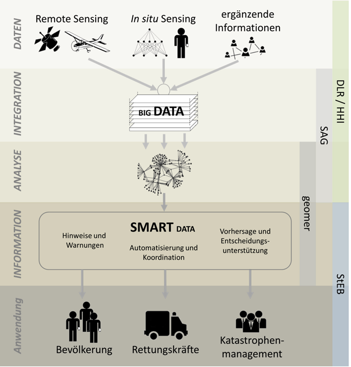
Remote sensing and usual information base
In situ sensing by mobile and fixed sensors
Complementary information through crowdsourcing
Integration, analysis and information in real time
The IT infrastructure included in the sd-kama platform integrates processing and analysis of a huge amount of heterogeneous data in real time. Big data technology allows integrating and analyzing data from different sources and displays information depending on user requirements. In addition to satellite and aerial survey data, information on water levels, traffic situations, stress levels of relief forces and information from social networks such as photos, videos and comments uploaded by disaster-affected citizens and rescue teams is available. All necessary steps for intelligent supply of information are fully automated. The project partners are developing effective integration processing and evaluation software tools. Project goal is the creation of a central standardized information platform, that allows efficient management of disaster from the local to the national level.
Applications for emergency managers
sd-kama ensures optimal data availability in all phases of disaster risk management cycle:
Preparedness:
sd-kama can simulate disasters and evaluate disaster training exercises. Risks and dangers can be located and evaluated for appropriate measures. Damage can be mitigated or even prevented. This includes the protection of critical infrastructure, the creation of suitable intervention plans in vulnerable areas, the setting of responsibilities as well as the deployment of technical protection measures.
Emergency response
With sd-kama, emergency operations centers get a single operating system that provides real time information. Thanks to complete situation maps, the head of operation can better assess the level of danger and take adequate action. All relevant information is available on a WebGIS. This contributes to efficient coordination of emergency services and optimal allocation of resources. The intelligent provision of information answers user-specific questions: What is the stress level of disaster relief forces? How fast do water levels rise? Which roads are still passable? Are hospitals, kindergartens or other elements at risk affected? How many technical equipment for disaster response is in stock? In addition, sd-kama informs the population and gives recommendations for action.
Recovery and mitigation
sd-kama allows to evaluate disaster development and intervention to identify weaknesses in coping. Future deployment plans can be further improved. Optimal data availability helps to organize reconstruction, e.g. by knowing which areas are accessible.
The project
sd-kama is funded by the Federal Ministry for Economic Affairs and Energy (BMWi) and is under the lead management of geomer. Other project partners are the German Aerospace Center (DLR), the Fraunhofer Heinrich Hertz Institute (HHI), Software AG and Stadtentwässerungsbetriebe Köln. The project started in April 2015 and is expected to last three years.
![]() geomer GmbH considers itself as a committed provider of geointelligent solutions for challenging geographical tasks. We are a young, independent company with private shareholders. Due to our scientific background and our excellence, we provide outstanding solutions – from consultancy to implementation. Our activities focus on products, solutions and project services in the areas of geointelligence, geospatial data, risk management and natural hazards. Our GIS solutions are open, flexible and easily scalable – whether it is a standard product for the visualization of company data, a single workstation solution or a group-wide information system. geomer has a quality management system according to DIN EN ISO 9001: 2008.
geomer GmbH considers itself as a committed provider of geointelligent solutions for challenging geographical tasks. We are a young, independent company with private shareholders. Due to our scientific background and our excellence, we provide outstanding solutions – from consultancy to implementation. Our activities focus on products, solutions and project services in the areas of geointelligence, geospatial data, risk management and natural hazards. Our GIS solutions are open, flexible and easily scalable – whether it is a standard product for the visualization of company data, a single workstation solution or a group-wide information system. geomer has a quality management system according to DIN EN ISO 9001: 2008.
![]() The flood protection centre (HSZ) is an administrative department with the Stadtentwässerungsbetriebe Köln, AöR (StEB) (The Group of Municipal Drainage Operations Cologne). The HSZ co-ordinates and watches the flood application in the Cologne city. It prepares the flood management, observes the discharge situation in the Rhine catchment area, provides water level forecast for the city of Cologne and informs the application forces and citizens. The involved offices and organizations act independently. Beside this job in the flood management, are among other things the sensitization of the population, consultation and committee work other important duties. Within this project the role of the HSZ is those of the user, so that the expert’s assessment is introduced, what the flood management supported and improved.
The flood protection centre (HSZ) is an administrative department with the Stadtentwässerungsbetriebe Köln, AöR (StEB) (The Group of Municipal Drainage Operations Cologne). The HSZ co-ordinates and watches the flood application in the Cologne city. It prepares the flood management, observes the discharge situation in the Rhine catchment area, provides water level forecast for the city of Cologne and informs the application forces and citizens. The involved offices and organizations act independently. Beside this job in the flood management, are among other things the sensitization of the population, consultation and committee work other important duties. Within this project the role of the HSZ is those of the user, so that the expert’s assessment is introduced, what the flood management supported and improved.
![]() DLR is the national aeronautics and space research center of the Federal Republic of Germany. Its extensive research and development work in aeronautics, space, energy, transport and security is integrated into national and international cooperative ventures. In addition to its own research, as Germany’s space agency, DLR has been given responsibility by the federal government for the planning and implementation of the German space program. DLR is also the umbrella organization for the nation’s largest project management agency. In the framework of the technology program “Smart Data” the department “Geo-Risks and Civil Security” of the German Remote Sensing Data Center (DFD) holds responsible for the project implementation on behalf of DLR. The department’s focus work lies in the development and applications of methods in the context of natural hazards research based on techniques of satellite-based earth observation. DFD and DLR’s Remote Sensing Technology Institute (IMF) together comprise the Earth Observation Center EOC, which has become a center of competence for earth observation in Germany.
DLR is the national aeronautics and space research center of the Federal Republic of Germany. Its extensive research and development work in aeronautics, space, energy, transport and security is integrated into national and international cooperative ventures. In addition to its own research, as Germany’s space agency, DLR has been given responsibility by the federal government for the planning and implementation of the German space program. DLR is also the umbrella organization for the nation’s largest project management agency. In the framework of the technology program “Smart Data” the department “Geo-Risks and Civil Security” of the German Remote Sensing Data Center (DFD) holds responsible for the project implementation on behalf of DLR. The department’s focus work lies in the development and applications of methods in the context of natural hazards research based on techniques of satellite-based earth observation. DFD and DLR’s Remote Sensing Technology Institute (IMF) together comprise the Earth Observation Center EOC, which has become a center of competence for earth observation in Germany.
![]() At the heart of Fraunhofer Heinrich Hertz Institute’s research work are developments of modern communication networks and multimedia systems. The core competencies of Fraunhofer HHI are in the areas of photonic networks and systems, fiber optic sensor systems and video coding and transmission. The Video Coding & Analytics Department (VCA) addresses all aspects in the research fields of image and video coding, transport of multimedia data, embedded multimedia processing, data analysis as well as image and video understanding, and the in sd-kama involved Image & Video Understanding group (IVU) develops innovative technology and products for automatic extraction, creation, annotation and deployment of semantic information from image and video data from various sources, e.g. digital archives, camera sensors or mobile devices like smartphones
At the heart of Fraunhofer Heinrich Hertz Institute’s research work are developments of modern communication networks and multimedia systems. The core competencies of Fraunhofer HHI are in the areas of photonic networks and systems, fiber optic sensor systems and video coding and transmission. The Video Coding & Analytics Department (VCA) addresses all aspects in the research fields of image and video coding, transport of multimedia data, embedded multimedia processing, data analysis as well as image and video understanding, and the in sd-kama involved Image & Video Understanding group (IVU) develops innovative technology and products for automatic extraction, creation, annotation and deployment of semantic information from image and video data from various sources, e.g. digital archives, camera sensors or mobile devices like smartphones
![]() Software AG empowers customers to innovate, differentiate and win in the digital world. Its products help companies combine existing systems on-premise and in the cloud into a single platform to optimize and digitize their businesses. The combination of process management, data integration and real-time analytics in one Digital Business Platform enables customers to drive operational efficiency, modernize their systems and optimize processes for smarter decision-making. Building on over 45 years of customer-centric innovation, Software AG is ranked a leader in many innovative IT categories. Software AG has more than 4,300 employees in 70 countries and had total revenues of €873 million in 2015.
Software AG empowers customers to innovate, differentiate and win in the digital world. Its products help companies combine existing systems on-premise and in the cloud into a single platform to optimize and digitize their businesses. The combination of process management, data integration and real-time analytics in one Digital Business Platform enables customers to drive operational efficiency, modernize their systems and optimize processes for smarter decision-making. Building on over 45 years of customer-centric innovation, Software AG is ranked a leader in many innovative IT categories. Software AG has more than 4,300 employees in 70 countries and had total revenues of €873 million in 2015.
News (in German only)
- Präsentation sd-kama auf der CeBIT 2016
- 14.03.-18.03.16: sd-kama auf der CeBIT, Halle 6, Stand C38
- Pressemitteilung der geomer GmbH vom 08.02.2016: Smart Data im Katastrophenmanagement
- IT-Director Ausgabe 6/2015: Prozesse für die IT von morgen
- Pressemitteilung des BMWi vom 19.06.2015: „Smart Data“ – Projekte des neuen BMWi-Technologieprogramms sind ausgewählt